Basic Information

The National Park Service Mobile App is a great tool for planning your trip, then it can be used as a guide during your visit. You can download the maps and content from Grand Canyon National Park for offline use. It’s especially handy if you’re exploring remote areas or concerned about data limits. Free and available now.
Visit this webpage (updated daily) for the current list of what is open and closed, and the hours of operation.
Physical Address
Directions
Operating Hours & Seasons
Weather
Fees & Passes
Visitor Centers
Internet & Cellular Access
 engulfed by evening shadows." width="" />
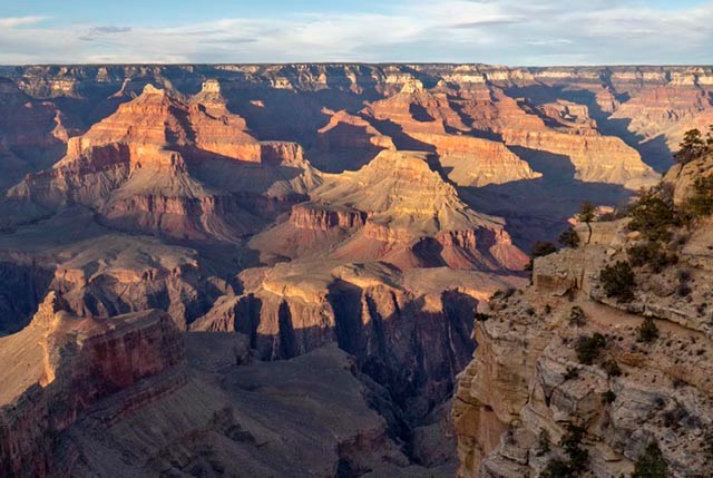
A Mile-Deep Canyon
The Grand Canyon of the Colorado River is a mile-deep canyon (1.6 km) that bisects the park.
Even though the average distance across the canyon is only 10 miles/ 16 km, it takes 5 hours to drive the 215 miles / 346 km between the park's South Rim Village and the North Rim Village.
How Do People Get Across Grand Canyon?
There is only one way to cross the Colorado River by automobile, and that is 137 miles / 231 km from the South Rim Village (at Marble Canyon, AZ) via the Navajo Bridge, a few miles downstream from Lees Ferry, where the Canyon is only 400 feet/ 122 m wide.
- It takes 4 to 5 hours to drive the 215 miles / 346 km between the park's South Rim Village and the North Rim Village.
If you are hiking across the canyon, it is a 21 mile/ 34 km hike to go "Rim To Rim," with a vertical descent - followed by a climb - of 1 mile/ 1.6 km.
- This is an overnight hiking trip for 95% of individuals, and most people really shouldn't attempt it during the hot summer months, when high temperatures often average over 105 F. (40 C)
Hikers cross the Colorado River on a narrow foot bridge 70 feet/ 21 m above the water.
All Visitors MUST have an Entrance Pass
90% of Travelers Visit Grand Canyon National Park's South Rim
South Rim
- The South Rim is open 24 hours a day, 365 days a year.
All visitor services: camping,lodging, and food are available year round.
- Reservations are strongly recommended during spring, summer and fall.
Make South Rim Lodging Reservation information here > -- Make South Rim Campground Reservations here >
- Because the South Rim is easier to get to, day-use visitors should expect traffic congestion and parking problems, especially during spring break and during summer months.
- The least crowded time is November through February. However, winter weather is a major consideration when planning a trip during these months.
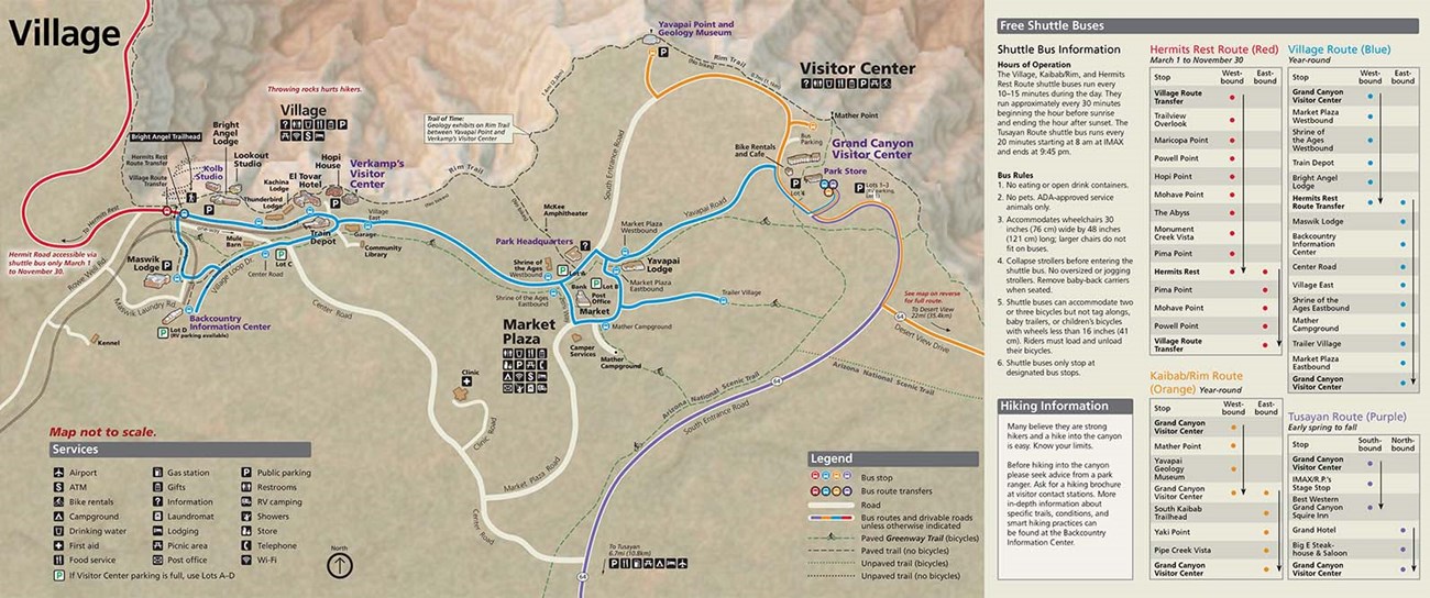
- A free shuttle bus system operates on the South Rim, in the Grand Canyon Village area. Save gas and frustration; park your vehicle and ride the free shuttles around the park.
- The South Rim of Grand Canyon averages 7000 feet/2134m above sea level. Walking at this elevation can be strenuous.
Visitors with respiratory or heart problems may experience difficulties.
- South Rim locations include (from west to east)
Scenic Hermit Road — Grand Canyon Village — Desert View Drive — Desert View
South Rim Pocket Map and Services Guide
North Rim is Open for the Season
The North Rim has a short season (May 15 through October 15), is harder to get to, and is more wild and secluded. Between October 16 and November 30, 2024, the North Rim is open for Day Use Only.
Lodging and camping reservations are recommended.
- North Rim 2024 Lodging Reservations
- North Rim 2024 Campground Reservations
Additional facilities are available in the surrounding Kaibab National Forest, the Kaibab Lodge area, and Jacob Lake.
- Driving Directions to the North Rim.
- Visitors with respiratory or heart problems may experience difficulties. Walking at this elevation can be strenuous.
- The North Rim is closed to all vehicles between December 1st and May 15th, and no visitor services are available.
- Additional North Rim Information and Video >
North Rim Pocket Map and Services Guide


The Inner Canyon
Includes everything below the rim and is seen mainly by hikers, backpackers, mule riders, or river runners.
- The inner canyon is a harsh desert environment with little shade and summer temperatures over 100°F. (>38°C).
- Introduction to Backcountry Hiking Brochure(download)
- Critical Backcountry Updates: Including Trail Closures and Restrictions (webpage)
There are many opportunities here for adventurous and hardy persons to backpack, camp, take a mule trip to Phantom Ranch, or take a river trip through Grand Canyon on the Colorado River. River Trips can last anywhere from several days to three weeks. There are no one-day river trips through the length of Grand Canyon.
Trail Courtesy Practices that Leave No Trace With so many of us participating in a wide range of trail activities, it really helps when we are considerate of each other. Trail Courtesy Guidelines help protect Grand Canyon's plants, animals and history, and enhance everyone's experience.
Safety Message:
Grand Canyon is in a Remote Part of the Country
- Bring an extra set of car keys; it could be a long wait for a locksmith.
- The closest camera repair shop is in Phoenix, Arizona.
- There is an automobile mechanic on the South Rim, but only for minor repairs. Most likely the car will have to be towed to Flagstaff or Williams, AZ .
- Distances are deceiving in this part of the country. It may look like you can visit three parks in one day, but reality is often different.
- Keep your gas tank full. The next gas station may be quite a distance down the road.
- Carry several gallons of water in your car, particularly during summer months.
Lightning Danger
Summer thunderstorms (July - September) provide beauty, excitement, and much needed water to Grand Canyon, but they also bring risk. Dangerous, potentially deadly, lightning accompanies thunderstorms. Lightning has killed and injured visitors to the park. Learn more >
